
Thank you for supporting this site ❤️
Make a donation
Make a donation
Gear up for your next adventure:
As an Amazon Associate, this site earns from qualifying purchases at no extra cost to you.
Wiener Neustadt topographic map
Click on the map to display elevation.
Thank you for supporting this site ❤️
Make a donation
Make a donation
Gear up for your next adventure:
As an Amazon Associate, this site earns from qualifying purchases at no extra cost to you.
About this map
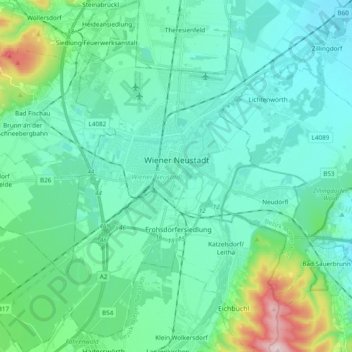
Name: Wiener Neustadt topographic map, elevation, terrain.
Location: Wiener Neustadt, Lower Austria, Austria (47.74268 16.14651 47.87157 16.28590)
Average elevation: 299 m
Minimum elevation: 232 m
Maximum elevation: 621 m
Thank you for supporting this site ❤️
Make a donation
Make a donation
Gear up for your next adventure:
As an Amazon Associate, this site earns from qualifying purchases at no extra cost to you.
Other topographic maps
Click on a map to view its topography, its elevation and its terrain.
Lahnberg
Austria > Lower Austria > Bezirk Neunkirchen > Schwarzau im Gebirge
Average elevation: 1,213 m