
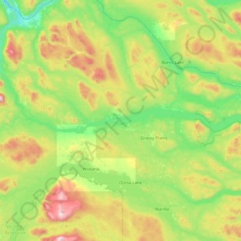
François Lake topographic map
Interactive map
Click on the map to display elevation.
François Lake topographic map, elevation, terrain
François Lake
Equity Silver is a weather station roughly 20 km (12.4 miles) north of François Lake, at an elevation of 1280 m (4199 ft). Equity Silver has a subarctic climate (Köppen Dfc), bordering on a tundra climate (Köppen ET).
About this map
Name: François Lake topographic map, elevation, terrain.
Average elevation: 984 m
Minimum elevation: 564 m
Maximum elevation: 2,251 m
Routes: Regional District of Bulkley-Nechako GPS tracks, routes, trails, hikes
Other topographic maps
Click on a map to view its topography, its elevation and its terrain.
Grassy Plains
Canada > British Columbia > Regional District of Bulkley-Nechako > Area E (Ootsa Lake/François Lake)
Average elevation: 911 m