
Make a donation
Gear up for your next adventure:
As an Amazon Associate, this site earns from qualifying purchases at no extra cost to you.
Ilidža topographic map
Click on the map to display elevation.
Make a donation
Gear up for your next adventure:
As an Amazon Associate, this site earns from qualifying purchases at no extra cost to you.
About this map
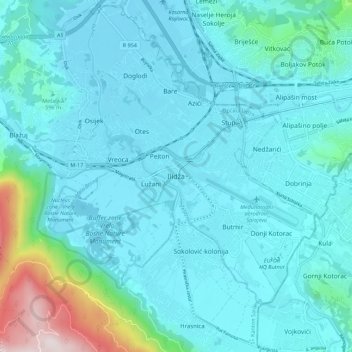
Name: Ilidža topographic map, elevation, terrain.
Average elevation: 581 m
Minimum elevation: 481 m
Maximum elevation: 1,273 m
Make a donation
Gear up for your next adventure:
As an Amazon Associate, this site earns from qualifying purchases at no extra cost to you.
Other topographic maps
Click on a map to view its topography, its elevation and its terrain.
Hubjeri
Bosnia and Herzegovina > Federation of Bosnia and Herzegovina > City of Goražde > Hubjeri
Average elevation: 454 m
Grlovnica
Bosnia and Herzegovina > Federation of Bosnia and Herzegovina > Rastovci
Average elevation: 619 m
Blidinje jezero
Bosnia and Herzegovina > Federation of Bosnia and Herzegovina
It is located at an elevation of 1,185 metres (3,888 ft) above sea level and is 2.5 kilometres (1.6 mi) long and 2.1 kilometres (1.3 mi) wide. Maximal depth of the lake is only 4.5 metres (15 ft), while average depth is around 1 metre (3.3 ft). The lake area varies from 2.5 to 6 km2, and the average depth is…
Average elevation: 1,242 m
City of Sarajevo
Bosnia and Herzegovina > Federation of Bosnia and Herzegovina > City of Sarajevo
Average elevation: 810 m
Make a donation
Gear up for your next adventure:
As an Amazon Associate, this site earns from qualifying purchases at no extra cost to you.