Geolocate

Pessac topographic map

Click on the map to display elevation.

About this map
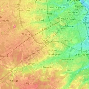
Name: Pessac topographic map, elevation, terrain.

Location: Pessac, Bordeaux, Gironde, Nouvelle-Aquitaine, Metropolitan France, 33600, France (44.74954 -0.75879 44.82258 -0.60295)

Average elevation: 36 m

Minimum elevation: -1 m

Maximum elevation: 70 m

Other topographic maps

Click on a map to view its topography, its elevation and its terrain.

Cité du Quillet

France > Nouvelle-Aquitaine > Gironde > Bazas

Average elevation: 102 m

Gear up for your next adventure:

💧Reusable Water Bottle - Durable water bottles for hydration on trails
🌡️Emergency Mylar Blankets - Compact thermal protection for unexpected nights outdoors
🧤Thermal Hiking Gloves - Grip-enhanced gloves for cold-weather altitude trekking
🧼Travel Hand Sanitizer - Keep hands clean when water is scarce
🥾Waterproof Hiking Boots - Boots keeping your feet dry in wet conditions

As an Amazon Associate, this site earns from qualifying purchases at no extra cost to you.