Geolocate

Pisa topographic map

Click on the map to display elevation.

About this map

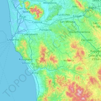
Name: Pisa topographic map, elevation, terrain.

Location: Pisa, Tuscany, Italy (43.10849 10.25750 43.83439 11.01401)

Average elevation: 137 m

Minimum elevation: -5 m

Maximum elevation: 1,037 m

Other topographic maps

Click on a map to view its topography, its elevation and its terrain.

Scarperia

Italy > Tuscany > Florence

Average elevation: 275 m

Tole

Italy > Tuscany > Florence > Marradi

Average elevation: 658 m

Vallombrosa

Italy > Tuscany > Florence > Reggello

Average elevation: 1,004 m

Santa Chiara

Italy > Tuscany > Siena > San Gimignano

Average elevation: 255 m

Bettolle

Italy > Tuscany > Siena > Sinalunga

Average elevation: 260 m

Modena

Italy > Tuscany > Siena > Sovicille > Recenza

Average elevation: 319 m

Castagneto

Italy > Tuscany > Arezzo > Cetica

Average elevation: 790 m

Bellavista

Italy > Tuscany > Arezzo > Ambra

Average elevation: 314 m

Via Nova

Italy > Tuscany > Pistoia > Via Nova

Average elevation: 18 m

San Piero

Italy > Tuscany > Arezzo > Ortignano Raggiolo > San Piero

Average elevation: 471 m

Gear up for your next adventure:

🥾Hiking Shorts - Breathable shorts suitable for summer hikes
🥾Approach Boots - Comfortable boots for hiking and climbing approaches
🥫Freeze-Dried Meals - Lightweight, high-calorie nutrition for multi-day treks
🧊Portable Cooler - Keep food and drinks cold during outdoor adventures
🧢Sun Protection Cap - Breathable cap to protect from sun exposure

As an Amazon Associate, this site earns from qualifying purchases at no extra cost to you.