Geolocate

Paderborn topographic map

Click on the map to display elevation.

About this map

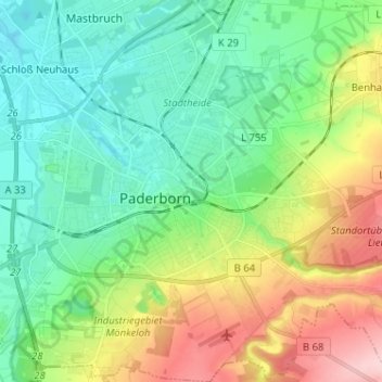
Name: Paderborn topographic map, elevation, terrain.

Location: Paderborn, Kreis Paderborn, North Rhine-Westphalia, Germany (51.67937 8.71049 51.75880 8.83549)

Average elevation: 155 m

Minimum elevation: 98 m

Maximum elevation: 278 m

Gear up for your next adventure:

🧴Sunscreen SPF - Broad-spectrum sunscreen for outdoor activities
🌬️Windproof Camp Stove - Efficient cooking even on exposed mountain peaks
🎒Backpack Rain Cover - External shield to keep your entire pack dry
🥽Outdoor Goggles - Protective eyewear for outdoor activities
🥾Waterproof Hiking Boots - Essential footwear for rugged terrain and wet Canadian trails

As an Amazon Associate, this site earns from qualifying purchases at no extra cost to you.