Geolocate

Lembata topographic map

Click on the map to display elevation.

About this map

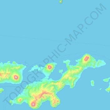
Name: Lembata topographic map, elevation, terrain.

Location: Lembata, East Nusa Tenggara, Indonesia (-8.58576 123.20546 -7.77828 123.92423)

Average elevation: 58 m

Minimum elevation: 0 m

Maximum elevation: 1,622 m

Gear up for your next adventure:

💧Hydration Bladder - Hands-free hydration solution for long treks
🧦Outdoor Socks - Durable socks designed for hiking and outdoor sports
👟Sport Hiking Sandals - Breathable footwear for water crossings and camp rest
🗺️Topographic Maps - Detailed maps to explore trails, mountains, and wilderness areas
🥾Approach Boots - Comfortable boots for hiking and climbing approaches

As an Amazon Associate, this site earns from qualifying purchases at no extra cost to you.