Geolocate

Redondela topographic map

Click on the map to display elevation.

About this map

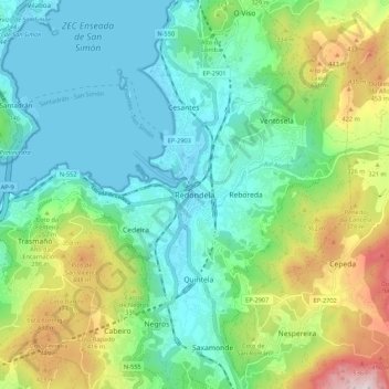
Name: Redondela topographic map, elevation, terrain.

Location: Redondela, Vigo, Pontevedra, Galicia, 36818, Spain (42.24422 -8.64860 42.32422 -8.56860)

Average elevation: 188 m

Minimum elevation: 0 m

Maximum elevation: 670 m

Gear up for your next adventure:

🦯Trekking Poles - Reduced impact on joints for steep topographic climbs
💡Portable Camping Lamp - Rechargeable lamp for campsite lighting
💡Compact LED Flashlight - Powerful and portable flashlight for outdoor use
🥽Outdoor Goggles - Protective eyewear for outdoor activities
🥾Trail Hiking Boots - Supportive boots for rough trails

As an Amazon Associate, this site earns from qualifying purchases at no extra cost to you.