
Make a donation
Gear up for your next adventure:
As an Amazon Associate, this site earns from qualifying purchases at no extra cost to you.
Boulemane topographic map
Click on the map to display elevation.
Make a donation
Gear up for your next adventure:
As an Amazon Associate, this site earns from qualifying purchases at no extra cost to you.
Boulemane
Boulemane (Arabic: بولمان) is a city in northern of Middle Atlas Mountains in Morocco and the capital of Boulemane Province. It is located in the region of Fès-Meknès. It is the highest city in Morocco, sitting at an altitude of 2029 metres.
Make a donation
Gear up for your next adventure:
As an Amazon Associate, this site earns from qualifying purchases at no extra cost to you.
About this map
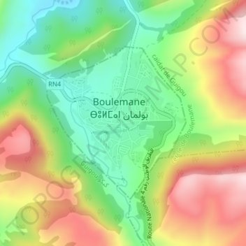
Name: Boulemane topographic map, elevation, terrain.
Average elevation: 1,816 m
Minimum elevation: 1,622 m
Maximum elevation: 2,067 m
Make a donation
Gear up for your next adventure:
As an Amazon Associate, this site earns from qualifying purchases at no extra cost to you.