
Make a donation
Gear up for your next adventure:
As an Amazon Associate, this site earns from qualifying purchases at no extra cost to you.
Vargas State topographic map
Click on the map to display elevation.
Make a donation
Gear up for your next adventure:
As an Amazon Associate, this site earns from qualifying purchases at no extra cost to you.
About this map
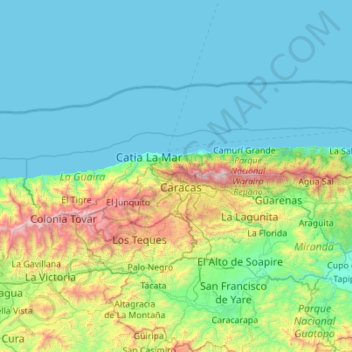
Name: Vargas State topographic map, elevation, terrain.
Location: Vargas State, Venezuela (10.38804 -67.41225 10.69044 -66.30646)
Average elevation: 419 m
Minimum elevation: -1 m
Maximum elevation: 2,693 m
Make a donation
Gear up for your next adventure:
As an Amazon Associate, this site earns from qualifying purchases at no extra cost to you.
Other topographic maps
Click on a map to view its topography, its elevation and its terrain.
Make a donation
Gear up for your next adventure:
As an Amazon Associate, this site earns from qualifying purchases at no extra cost to you.
Puerto La Cruz
Venezuela > Anzoategui State > Municipio Juan Antonio Sotillo > Puerto La Cruz
Average elevation: 97 m
Picacho del Diablo
Venezuela > Carabobo State > Municipio San Diego > Parroquia San Diego
Average elevation: 1,310 m
Make a donation
Gear up for your next adventure:
As an Amazon Associate, this site earns from qualifying purchases at no extra cost to you.