Geolocate

Friedberg topographic map

Click on the map to display elevation.

About this map

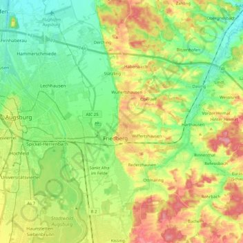
Name: Friedberg topographic map, elevation, terrain.

Location: Friedberg, Landkreis Aichach-Friedberg, Bavaria, 86316, Germany (48.29778 10.93378 48.43101 11.08028)

Average elevation: 493 m

Minimum elevation: 454 m

Maximum elevation: 552 m

Other topographic maps

Click on a map to view its topography, its elevation and its terrain.

Pichl

Germany > Bavaria > Landkreis Aichach-Friedberg

Average elevation: 477 m

Lindl

Germany > Bavaria > Landkreis Aichach-Friedberg

Average elevation: 489 m

Gear up for your next adventure:

🥾Lightweight Hiking Boots - Boots for comfort and mobility on long hikes
🎒Fully Waterproof Backpack - Total protection for photography gear and electronics
🛶Canoe Life Vest - Safety vest for water sports
🥾Trail Hiking Boots - Supportive boots for rough trails
🧴Insect Repellent - Protect yourself from bugs during outdoor adventures

As an Amazon Associate, this site earns from qualifying purchases at no extra cost to you.