
Make a donation
Gear up for your next adventure:
As an Amazon Associate, this site earns from qualifying purchases at no extra cost to you.
Plaza Avaroa topographic map
Click on the map to display elevation.
Make a donation
Gear up for your next adventure:
As an Amazon Associate, this site earns from qualifying purchases at no extra cost to you.
About this map
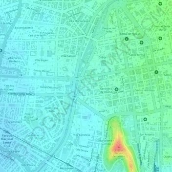
Name: Plaza Avaroa topographic map, elevation, terrain.
Average elevation: 2,566 m
Minimum elevation: 2,553 m
Maximum elevation: 2,612 m
Make a donation
Gear up for your next adventure:
As an Amazon Associate, this site earns from qualifying purchases at no extra cost to you.
Other topographic maps
Click on a map to view its topography, its elevation and its terrain.
Make a donation
Gear up for your next adventure:
As an Amazon Associate, this site earns from qualifying purchases at no extra cost to you.
Cochabamba
Bolivia > Cochabamba > Cercado > Cochabamba
The valley of Cochabamba has been classified as a mesothermal valley. The basin floor has an average elevation of 2600 m but at its lowest point in the east it runs at 2480 m. Surrounding mountains vary in height with the highest elevation in vicinity of valley being Tunari with 5,023 m a.s.l. The city is…
Average elevation: 2,953 m