Geolocate

Seaham topographic map

Click on the map to display elevation.

About this map
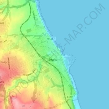
Name: Seaham topographic map, elevation, terrain.

Location: Seaham, County Durham, North East, England, United Kingdom (54.81751 -1.37868 54.86072 -1.31863)

Average elevation: 31 m

Minimum elevation: 0 m

Maximum elevation: 117 m

Other topographic maps

Click on a map to view its topography, its elevation and its terrain.
Flint Hill

United Kingdom > England > County Durham

Average elevation: 191 m

Wycliffe

United Kingdom > England > County Durham

Average elevation: 129 m

Durham

United Kingdom > England > County Durham

Average elevation: 119 m

Gear up for your next adventure:

🚲Bike Repair Kit - Essential tools for on-trail mechanical issues
🔥Camping Stove - Portable stoves to cook outdoors with ease
🔦LED Headtorch - Bright and durable light for night activities
🛶Kayak Dry Bag - Waterproof storage for kayaking adventures
🧦Outdoor Socks - Durable socks designed for hiking and outdoor sports

As an Amazon Associate, this site earns from qualifying purchases at no extra cost to you.