
Thank you for supporting this site ❤️
Make a donation
Make a donation
Gear up for your next adventure:
As an Amazon Associate, this site earns from qualifying purchases at no extra cost to you.
Huế topographic map
Click on the map to display elevation.
Thank you for supporting this site ❤️
Make a donation
Make a donation
Gear up for your next adventure:
As an Amazon Associate, this site earns from qualifying purchases at no extra cost to you.
About this map
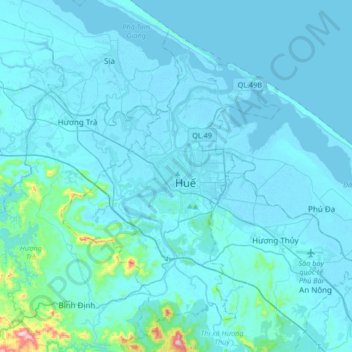
Name: Huế topographic map, elevation, terrain.
Location: Huế, Thuận Hóa Ward, Huế, 54000, Vietnam (16.30393 107.42634 16.62393 107.74634)
Average elevation: 30 m
Minimum elevation: -3 m
Maximum elevation: 563 m
Thank you for supporting this site ❤️
Make a donation
Make a donation
Gear up for your next adventure:
As an Amazon Associate, this site earns from qualifying purchases at no extra cost to you.