Geolocate

Granton topographic map

Click on the map to display elevation.

About this map

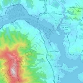
Name: Granton topographic map, elevation, terrain.

Location: Granton, Hobart, City of Glenorchy, Tasmania, Australia (-42.78670 147.13366 -42.74035 147.24939)

Average elevation: 138 m

Minimum elevation: -3 m

Maximum elevation: 884 m

Gear up for your next adventure:

🥾Trail Hiking Boots - Supportive boots for rough trails
🚲Bike Repair Kit - Essential tools for on-trail mechanical issues
🧳Compression Sacks - Maximize space in your backpack by shrinking gear
🥾Trail Running Boots - Durable shoes designed for trail running
🧢Beanie Hat - Keep your head warm in cold weather

As an Amazon Associate, this site earns from qualifying purchases at no extra cost to you.