Geolocate

Praha 1 topographic map

Click on the map to display elevation.

About this map
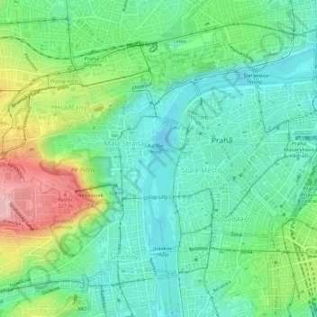
Name: Praha 1 topographic map, elevation, terrain.

Location: Praha 1, Prague, obvod Praha 1, Capital City of Prague, Prague, Czechia (50.07558 14.38484 50.09542 14.43799)

Average elevation: 230 m

Minimum elevation: 177 m

Maximum elevation: 349 m

Other topographic maps

Click on a map to view its topography, its elevation and its terrain.
White Mountain

Czechia > Prague > Capital City of Prague

Average elevation: 346 m

Gear up for your next adventure:

🥾Mountaineering Boots - Supportive boots for climbing and high-altitude hiking
🎒Backpack Rain Cover - External shield to keep your entire pack dry
🔥Camping Stove - Portable stoves to cook outdoors with ease
🧥Ultralight Puffy Jacket - Maximum warmth that packs down to the size of an orange
🔨Vehicle Emergency Tool - Safety tool for remote road trips to trailheads

As an Amazon Associate, this site earns from qualifying purchases at no extra cost to you.