Geolocate

Budakalász topographic map

Click on the map to display elevation.

About this map

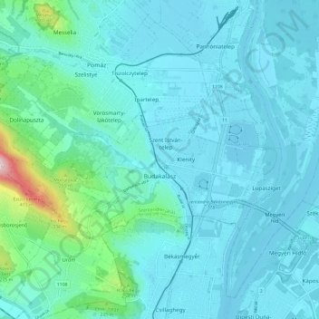
Name: Budakalász topographic map, elevation, terrain.

Location: Budakalász, Szentendrei járás, Pest, Central Hungary, Hungary (47.60604 18.97565 47.63966 19.09173)

Average elevation: 143 m

Minimum elevation: 98 m

Maximum elevation: 471 m

Other topographic maps

Click on a map to view its topography, its elevation and its terrain.

Danube

Hungary > Pest > Göd

Average elevation: 111 m

Dunakeszi

Hungary > Pest > Dunakeszi > Dunakeszi

Average elevation: 124 m

Gear up for your next adventure:

🥾Hiking Leggings - Comfortable leggings for outdoor activities
🌬️Windproof Camp Stove - Efficient cooking even on exposed mountain peaks
🧴Waterproofing Spray - Restore the DWR coating on jackets and tents
🧦Hiking Socks - Moisture-wicking and comfortable socks for long hikes
🧥Thermal Layer - Insulating layer for cold outdoor conditions

As an Amazon Associate, this site earns from qualifying purchases at no extra cost to you.