
Make a donation
Gear up for your next adventure:
As an Amazon Associate, this site earns from qualifying purchases at no extra cost to you.
Berlín topographic map
Click on the map to display elevation.
Make a donation
Gear up for your next adventure:
As an Amazon Associate, this site earns from qualifying purchases at no extra cost to you.
Berlín
Berlín has depended on coffee since its foundation. Most of the territory surrounding the city is coffee farms. The highlands of Berlín lend themselves to this crop, which is typical of high-altitude lands. In the rural parts of Berlín, there is subsistence agriculture (minimal production only to supply the needs of a farmer and their family) consisting of corn and beans. When there is a surplus production of basic grains (corn and beans), it is marketed mainly in the urban area of Berlín. The production of minor species such as poultry is also oriented for self-consumption and on a smaller scale for sales. Some sources tell that a possible introduction for coffee in El Salvador occurred between 1800 and 1815 in the Ahuachapán Department, where it then spread throughout the nation.
Make a donation
Gear up for your next adventure:
As an Amazon Associate, this site earns from qualifying purchases at no extra cost to you.
About this map
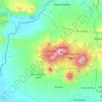
Name: Berlín topographic map, elevation, terrain.
Location: Berlín, Usulután, El Salvador (13.45713 -88.57032 13.53713 -88.49032)
Average elevation: 877 m
Minimum elevation: 318 m
Maximum elevation: 1,581 m
Make a donation
Gear up for your next adventure:
As an Amazon Associate, this site earns from qualifying purchases at no extra cost to you.
Other topographic maps
Click on a map to view its topography, its elevation and its terrain.