Geolocate

Condoto topographic map

Click on the map to display elevation.

About this map

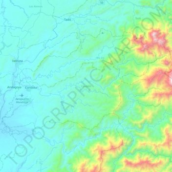
Name: Condoto topographic map, elevation, terrain.

Location: Condoto, San Juan, Chocó, Colombia (4.97959 -76.72470 5.21182 -76.28808)

Average elevation: 320 m

Minimum elevation: 21 m

Maximum elevation: 2,019 m

Gear up for your next adventure:

👟Leg Gaiters - Keep debris, mud, and snow out of your boots
❄️Traction Ice Cleats - Slip-on spikes for icy trails and winter hiking
🧳Compression Sacks - Maximize space in your backpack by shrinking gear
🪑Ultralight Camping Stool - Compact seating for rest stops during long hikes
Family Camping Tent - Spacious tent suitable for family camping trips

As an Amazon Associate, this site earns from qualifying purchases at no extra cost to you.