
Thank you for supporting this site ❤️
Make a donation
Make a donation
Gear up for your next adventure:
As an Amazon Associate, this site earns from qualifying purchases at no extra cost to you.
Wolfsville topographic map
Click on the map to display elevation.
Thank you for supporting this site ❤️
Make a donation
Make a donation
Gear up for your next adventure:
As an Amazon Associate, this site earns from qualifying purchases at no extra cost to you.
About this map
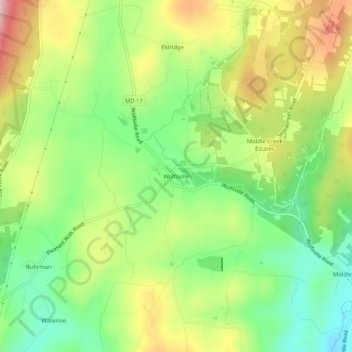
Name: Wolfsville topographic map, elevation, terrain.
Location: Wolfsville, Frederick County, Maryland, United States (39.55427 -77.57054 39.59427 -77.53054)
Average elevation: 341 m
Minimum elevation: 237 m
Maximum elevation: 481 m
Thank you for supporting this site ❤️
Make a donation
Make a donation
Gear up for your next adventure:
As an Amazon Associate, this site earns from qualifying purchases at no extra cost to you.
Other topographic maps
Click on a map to view its topography, its elevation and its terrain.
Catoctin Mountain Park
United States > Maryland > Frederick County > Thurmont
Average elevation: 422 m