
Make a donation
Gear up for your next adventure:
As an Amazon Associate, this site earns from qualifying purchases at no extra cost to you.
Ambato topographic map
Click on the map to display elevation.
Make a donation
Gear up for your next adventure:
As an Amazon Associate, this site earns from qualifying purchases at no extra cost to you.
Ambato
Ambato (Spanish pronunciation: [amˈbato]; full form, San Juan de Ambato; Quechua: Ampatu Llaqta) is a city located in the central Andean valley of Ecuador. Lying on the banks of the Ambato River, the city also sits beneath several tall mountains. It is the capital city of the Tungurahua Province, situated at an elevation of 2,577 meters above sea level. It is variously nicknamed "City of Flowers and Fruits", "Land of the Three Juan's", and "Garden of Ecuador." Ambato's inhabitants are called Ambateños or Guaytambos (after a type of native peach that the valley is famous for producing). The current mayor of Ambato is Diana Caiza.
Make a donation
Gear up for your next adventure:
As an Amazon Associate, this site earns from qualifying purchases at no extra cost to you.
About this map
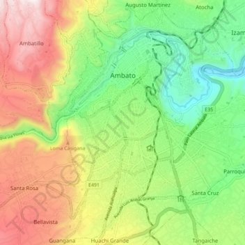
Name: Ambato topographic map, elevation, terrain.
Location: Ambato, Tungurahua, Ecuador (-1.30163 -78.65136 -1.21602 -78.56832)
Average elevation: 2,752 m
Minimum elevation: 2,345 m
Maximum elevation: 3,311 m
Make a donation
Gear up for your next adventure:
As an Amazon Associate, this site earns from qualifying purchases at no extra cost to you.
Other topographic maps
Click on a map to view its topography, its elevation and its terrain.