
Thank you for supporting this site ❤️
Make a donation
Make a donation
Gear up for your next adventure:
As an Amazon Associate, this site earns from qualifying purchases at no extra cost to you.
Udakanda topographic map
Click on the map to display elevation.
Thank you for supporting this site ❤️
Make a donation
Make a donation
Gear up for your next adventure:
As an Amazon Associate, this site earns from qualifying purchases at no extra cost to you.
About this map
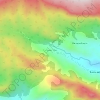
Name: Udakanda topographic map, elevation, terrain.
Location: Udakanda, Ratnapura District, Sabaragamuwa Province, Sri Lanka (6.71313 80.56600 6.75313 80.60600)
Average elevation: 986 m
Minimum elevation: 669 m
Maximum elevation: 1,372 m
Thank you for supporting this site ❤️
Make a donation
Make a donation
Gear up for your next adventure:
As an Amazon Associate, this site earns from qualifying purchases at no extra cost to you.