Geolocate

Fundación topographic map

Click on the map to display elevation.

About this map

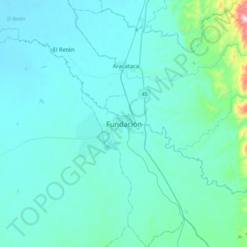
Name: Fundación topographic map, elevation, terrain.

Location: Fundación, Magdalena, Colombia (10.35557 -74.35011 10.67557 -74.03011)

Average elevation: 96 m

Minimum elevation: 5 m

Maximum elevation: 1,120 m

Gear up for your next adventure:

🥾Trail Running Boots - Durable shoes designed for trail running
🦯Trekking Poles - Reduced impact on joints for steep topographic climbs
🥾Trail Hiking Boots - Supportive boots for rough trails
💧Hydration Bladder - Hands-free hydration solution for long treks
Lightweight Camping Tent - Portable shelter optimized for Canadian backcountry camping

As an Amazon Associate, this site earns from qualifying purchases at no extra cost to you.