
Make a donation
Gear up for your next adventure:
As an Amazon Associate, this site earns from qualifying purchases at no extra cost to you.
Île de Ré topographic map
Click on the map to display elevation.
Make a donation
Gear up for your next adventure:
As an Amazon Associate, this site earns from qualifying purchases at no extra cost to you.
Île de Ré
Île de Ré (French pronunciation: ; variously spelled Rhé or Rhéa; Poitevin: ile de Rét; English: Ré Island, /reɪ/ RAY) is an island off the west coast of France near La Rochelle, Charente-Maritime, on the northern side of the Pertuis d'Antioche strait. Its highest point has an elevation of 20 metres (66 feet). It is 30 kilometres (19 miles) long and five kilometres (3 miles) wide. The 2.9 km (1.8 mi) Île de Ré bridge, completed in 1988, connects it to La Rochelle on the mainland.
Make a donation
Gear up for your next adventure:
As an Amazon Associate, this site earns from qualifying purchases at no extra cost to you.
About this map
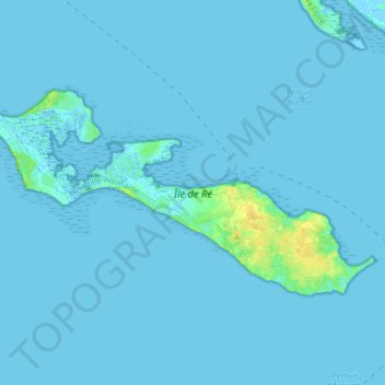
Name: Île de Ré topographic map, elevation, terrain.
Average elevation: 1 m
Minimum elevation: -3 m
Maximum elevation: 16 m
Make a donation
Gear up for your next adventure:
As an Amazon Associate, this site earns from qualifying purchases at no extra cost to you.