
Wilmette topographic map
Click on the map to display elevation.
Wilmette
Between 1900 and 1920 the village saw its population more than triple to 7,814. In 1922 the village adopted the "Plan of Wilmette," which outlined a vision for its future that included open spaces along Green Bay Road and the elevation of the railroad tracks to provide unobstructed flow of traffic between the east and west parts of the village. While few of these specific plans ever materialized, the 1922 plan represents the beginning of zoning as a mode of shaping the village's development.
About this map
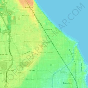
Name: Wilmette topographic map, elevation, terrain.
Average elevation: 187 m
Minimum elevation: 175 m
Maximum elevation: 207 m
Other topographic maps
Click on a map to view its topography, its elevation and its terrain.
Chicago, North Shore & Milwaukee
United States > Illinois > Cook County > Northbrook > Williamsburg Square
Average elevation: 198 m