
Make a donation
Gear up for your next adventure:
As an Amazon Associate, this site earns from qualifying purchases at no extra cost to you.
Tunis topographic map
Click on the map to display elevation.
Make a donation
Gear up for your next adventure:
As an Amazon Associate, this site earns from qualifying purchases at no extra cost to you.
Tunis
The city of Tunis is built on a hill slope down to the lake of Tunis. These hills contain places such as Notre-Dame de Tunis, Ras Tabia, La Rabta, La Kasbah, Montfleury, and La Manoubia with altitudes just above 50 metres (160 feet). The city is located at the crossroads of a narrow strip of land between Lake Tunis and Séjoumi. The isthmus between them is what geologists call the "Tunis dome", which includes hills of limestone and sediments. It forms a natural bridge and since ancient times several major roads linking to Egypt and elsewhere in Tunisia have branched out from it. The roads also connect with Carthage, emphasizing its political and economic importance not only in Tunisia but more widely in North Africa and the Mediterranean Sea in ancient times.
Make a donation
Gear up for your next adventure:
As an Amazon Associate, this site earns from qualifying purchases at no extra cost to you.
About this map
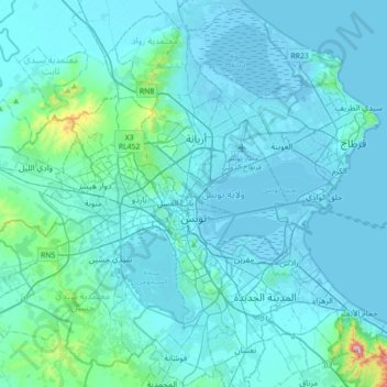
Name: Tunis topographic map, elevation, terrain.
Location: Tunis, Tunisia (36.69251 10.00379 36.94302 10.35481)
Average elevation: 37 m
Minimum elevation: -7 m
Maximum elevation: 542 m
Make a donation
Gear up for your next adventure:
As an Amazon Associate, this site earns from qualifying purchases at no extra cost to you.