Geolocate

Dyke topographic map

Click on the map to display elevation.

About this map

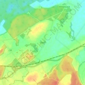
Name: Dyke topographic map, elevation, terrain.

Location: Dyke, Moray, Scotland, IV36 2TJ, United Kingdom (57.58425 -3.71358 57.62425 -3.67358)

Average elevation: 24 m

Minimum elevation: 4 m

Maximum elevation: 53 m

Gear up for your next adventure:

🔋Emergency Crank Radio - Weather alerts and power without needing batteries
Camping Essentials - All-in-one gear for a comfortable camping trip
🧦Hiking Socks - Moisture-wicking and comfortable socks for long hikes
🔦LED Headtorch - Bright and durable light for night activities
👟Sport Hiking Sandals - Breathable footwear for water crossings and camp rest

As an Amazon Associate, this site earns from qualifying purchases at no extra cost to you.