
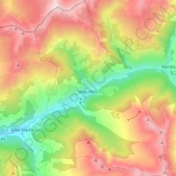
Aiguilles topographic map
Interactive map
Click on the map to display elevation.
About this map
Name: Aiguilles topographic map, elevation, terrain.
Average elevation: 2,154 m
Minimum elevation: 1,360 m
Maximum elevation: 3,066 m
Other topographic maps
Click on a map to view its topography, its elevation and its terrain.
Le Beynon
France > Provence-Alpes-Côte d'Azur > Hautes-Alpes > Ventavon
Le Beynon, Ventavon, Gap, Hautes-Alpes, Provence-Alpes-Côte d'Azur, Metropolitan France, 05300, France
Average elevation: 672 m
Abriès-Ristolas
France > Provence-Alpes-Côte d'Azur > Hautes-Alpes > Abriès-Ristolas
Abriès-Ristolas, Briançon, Hautes-Alpes, Provence-Alpes-Côte d'Azur, Metropolitan France, 05460, France
Average elevation: 2,293 m
Le Pied du Col
France > Provence-Alpes-Côte d'Azur > Hautes-Alpes > Villar-d'Arêne > Le Pied du Col
Le Pied du Col, Villar-d'Arêne, Briançon, Hautes-Alpes, Provence-Alpes-Côte d'Azur, Metropolitan France, 05480, France
Average elevation: 2,101 m
Notre-Dame du Laus
France > Provence-Alpes-Côte d'Azur > Hautes-Alpes > Saint-Étienne-le-Laus
Notre-Dame du Laus, Saint-Étienne-le-Laus, Gap, Hautes-Alpes, Provence-Alpes-Côte d'Azur, Metropolitan France, 05130, France
Average elevation: 951 m
Piton de la Viaclose
France > Provence-Alpes-Côte d'Azur > Hautes-Alpes > La Chapelle-en-Valgaudémar
Piton de la Viaclose, La Chapelle-en-Valgaudémar, Gap, Hautes-Alpes, Provence-Alpes-Côte d'Azur, Metropolitan France, 05800, France
Average elevation: 2,607 m
La Grave
France > Provence-Alpes-Côte d'Azur > Hautes-Alpes
La Grave, Briançon, Hautes-Alpes, Provence-Alpes-Côte d'Azur, Metropolitan France, 05320, France
Average elevation: 2,407 m
Saint-Véran
France > Provence-Alpes-Côte d'Azur > Hautes-Alpes
Saint-Véran, Briançon, Hautes-Alpes, Provence-Alpes-Côte d'Azur, Metropolitan France, 05350, France
Average elevation: 2,381 m