
Stowe topographic map
Interactive map
Click on the map to display elevation.
About this map
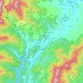
Name: Stowe topographic map, elevation, terrain.
Location: Stowe, Lamoille County, Vermont, United States (44.39830 -72.83830 44.56340 -72.59728)
Average elevation: 436 m
Minimum elevation: 174 m
Maximum elevation: 1,128 m
Other topographic maps
Click on a map to view its topography, its elevation and its terrain.
Jeffersonville
United States > Vermont > Lamoille County > Cambridge
Jeffersonville, Cambridge, Lamoille County, Vermont, 05464, United States
Average elevation: 188 m
Cambridge
United States > Vermont > Lamoille County > Cambridge
Cambridge, Lamoille County, Vermont, United States
Average elevation: 315 m