Geolocate

Tamalanrea topographic map

Click on the map to display elevation.

About this map

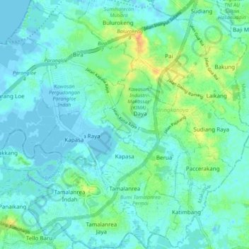
Name: Tamalanrea topographic map, elevation, terrain.

Location: Tamalanrea, Makassar, South Sulawesi, Sulawesi, Indonesia (-5.15180 119.44188 -5.06898 119.51942)

Average elevation: 8 m

Minimum elevation: -4 m

Maximum elevation: 32 m

Other topographic maps

Click on a map to view its topography, its elevation and its terrain.

Tidung Mariolo

Indonesia > South Sulawesi > Makassar > Tidung

Average elevation: 7 m

Gear up for your next adventure:

🕶️Polarized Sunglasses - Reduces glare from snow and water at high elevations
🚲MTB Frame Bag - Carry tools and maps directly on your bicycle frame
🧢Outdoor Cap - Protective cap for sun and rain during hikes
🛶Canoe Life Vest - Safety vest for water sports
🦶Anti-Blister Balm - Prevents friction and hotspots during long ascents

As an Amazon Associate, this site earns from qualifying purchases at no extra cost to you.