Geolocate

Hyden topographic map

Click on the map to display elevation.

About this map
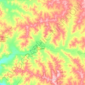
Name: Hyden topographic map, elevation, terrain.

Location: Hyden, Shire Of Kondinin, Western Australia, 6359, Australia (-32.59880 118.77919 -32.20357 119.57076)

Average elevation: 346 m

Minimum elevation: 267 m

Maximum elevation: 444 m

Other topographic maps

Click on a map to view its topography, its elevation and its terrain.
Kings Park

Australia > Western Australia > Perth

Average elevation: 31 m

Augusta

Australia > Western Australia > Augusta

Average elevation: 31 m

Watervalley Park

Australia > Western Australia

Average elevation: 29 m

Swan River

Australia > Western Australia

Average elevation: 113 m

Moorehead

Australia > Western Australia

Average elevation: 197 m

Honeymoon Bay

Australia > Western Australia

Average elevation: 7 m

Cooke Creek

Australia > Western Australia > Onslow

Average elevation: 2 m

Joondalup

Australia > Western Australia

Average elevation: 33 m

Gear up for your next adventure:

🧦Hiking Liner Socks - Thin base layer to prevent friction and blisters
⛺Tent Footprint - Protect tent floor and increase durability
🥾Trail Hiking Shoes - Durable shoes designed for rugged trails
🥾Approach Boots - Comfortable boots for hiking and climbing approaches
🎒Backpack Rain Cover - External shield to keep your entire pack dry

As an Amazon Associate, this site earns from qualifying purchases at no extra cost to you.