Geolocate

Sonthofen topographic map

Click on the map to display elevation.

About this map

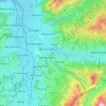
Name: Sonthofen topographic map, elevation, terrain.

Location: Sonthofen, Landkreis Oberallgäu, Bavaria, 87527, Germany (47.45954 10.25919 47.55159 10.37368)

Average elevation: 964 m

Minimum elevation: 719 m

Maximum elevation: 2,004 m

Other topographic maps

Click on a map to view its topography, its elevation and its terrain.

Häuser

Germany > Bavaria > Landkreis Oberallgäu > Burgberg

Average elevation: 762 m

Gear up for your next adventure:

🥫Freeze-Dried Meals - Lightweight, high-calorie nutrition for multi-day treks
🧰Emergency Multi-Tool - Compact multi-tool for outdoor survival
💡Compact LED Flashlight - Powerful and portable flashlight for outdoor use
🥾Hiking Boots - Sturdy boots providing ankle support and traction on rugged trails
👖Convertible Hiking Pants - Zip-off legs to adapt to changing weather conditions

As an Amazon Associate, this site earns from qualifying purchases at no extra cost to you.