
Thank you for supporting this site ❤️
Make a donation
Make a donation
Gear up for your next adventure:
As an Amazon Associate, this site earns from qualifying purchases at no extra cost to you.
Varel topographic map
Click on the map to display elevation.
Thank you for supporting this site ❤️
Make a donation
Make a donation
Gear up for your next adventure:
As an Amazon Associate, this site earns from qualifying purchases at no extra cost to you.
About this map
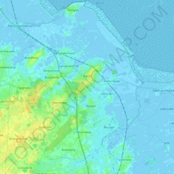
Name: Varel topographic map, elevation, terrain.
Location: Varel, Landkreis Friesland, Lower Saxony, 26316, Germany (53.32106 8.03220 53.45350 8.20775)
Average elevation: 3 m
Minimum elevation: -4 m
Maximum elevation: 19 m
Thank you for supporting this site ❤️
Make a donation
Make a donation
Gear up for your next adventure:
As an Amazon Associate, this site earns from qualifying purchases at no extra cost to you.