Geolocate

Santa Marta topographic map

Click on the map to display elevation.

About this map

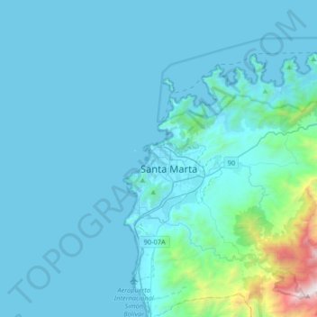
Name: Santa Marta topographic map, elevation, terrain.

Location: Santa Marta, Magdalena, 470004, Colombia (11.08223 -74.36556 11.40223 -74.04556)

Average elevation: 193 m

Minimum elevation: 0 m

Maximum elevation: 2,607 m

Gear up for your next adventure:

🥾Mountaineering Boots - Supportive boots for climbing and high-altitude hiking
🧦Outdoor Socks - Durable socks designed for hiking and outdoor sports
🏕️Camping Hammock - Integrated protection for sleeping between trees
🔨Vehicle Emergency Tool - Safety tool for remote road trips to trailheads
🧢Outdoor Cap - Protective cap for sun and rain during hikes

As an Amazon Associate, this site earns from qualifying purchases at no extra cost to you.