
Yamdena Island topographic map
Interactive map
Click on the map to display elevation.
About this map
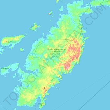
Name: Yamdena Island topographic map, elevation, terrain.
Location: Yamdena Island, Moluccas, Indonesia (-8.02984 131.07872 -7.11730 131.74681)
Average elevation: 20 m
Minimum elevation: -1 m
Maximum elevation: 275 m
Other topographic maps
Click on a map to view its topography, its elevation and its terrain.
Mount Kapalatmada
Mount Kapalatmada, Moluccas, Indonesia
Average elevation: 2,394 m
Ambon Island
Ambon Island, Ambon, Moluccas, Indonesia
Average elevation: 79 m