Geolocate

Unterreichenbach topographic map

Click on the map to display elevation.
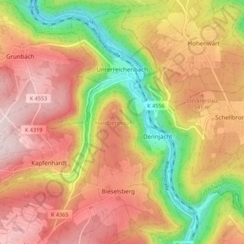
Unterreichenbach

Unterreichenbach is in the Nagold River Valley between Calw and Pforzheim, at an altitude of between 292 und 633 metres.

Wikipedia (CC-BY-SA 3.0)

About this map

Name: Unterreichenbach topographic map, elevation, terrain.

Location: Unterreichenbach, Verwaltungsgemeinschaft Bad Liebenzell, Landkreis Calw, Baden-Württemberg, Germany (48.79527 8.65376 48.83837 8.72955)

Average elevation: 493 m

Minimum elevation: 289 m

Maximum elevation: 651 m

Gear up for your next adventure:

Lightweight Camping Tent - Portable shelter optimized for Canadian backcountry camping
🧼Travel Hand Sanitizer - Keep hands clean when water is scarce
🥽Outdoor Goggles - Protective eyewear for outdoor activities
🛶Kayak Dry Bag - Waterproof storage for kayaking adventures
🌡️Emergency Mylar Blankets - Compact thermal protection for unexpected nights outdoors

As an Amazon Associate, this site earns from qualifying purchases at no extra cost to you.