Geolocate

Luxor topographic map

Click on the map to display elevation.

About this map

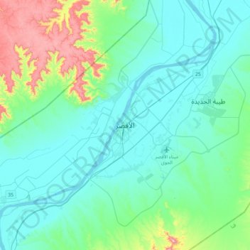
Name: Luxor topographic map, elevation, terrain.

Location: Luxor, 85951, Egypt (25.54210 32.48719 25.86210 32.80719)

Average elevation: 158 m

Minimum elevation: 65 m

Maximum elevation: 589 m

Other topographic maps

Click on a map to view its topography, its elevation and its terrain.

Luxor City

Egypt > Luxor

Average elevation: 78 m

Old Karnak

Egypt > Luxor

Average elevation: 78 m

Al Baairat Village

Egypt > Luxor

Average elevation: 95 m

Gear up for your next adventure:

🥽Outdoor Goggles - Protective eyewear for outdoor activities
Camping Essentials - All-in-one gear for a comfortable camping trip
🔥Emergency Fire Starter - Reliable ignition source for all weather conditions
🧭GPS Tracker - Track your location in remote areas safely
🥾Lightweight Hiking Boots - Boots for comfort and mobility on long hikes

As an Amazon Associate, this site earns from qualifying purchases at no extra cost to you.