
Western Province topographic map
Interactive map
Click on the map to display elevation.
About this map
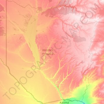
Name: Western Province topographic map, elevation, terrain.
Location: Western Province, Zambia (-17.63787 21.99935 -13.71273 25.58648)
Average elevation: 1,069 m
Minimum elevation: 927 m
Maximum elevation: 1,249 m
Other topographic maps
Click on a map to view its topography, its elevation and its terrain.
Mumbi
Zambia > Eastern Province > Mumbi
Mumbi, Petauke District, Eastern Province, Zambia
Average elevation: 1,017 m
Victoria Falls
Zambia > Southern Province > Livingstone
Victoria Falls, Livingstone, Livingstone District, Southern Province, Zambia
Average elevation: 875 m
Victoria Falls
Zambia > Southern Province > Livingstone
Victoria Falls, Livingstone, Southern Province, Zambia
Average elevation: 875 m
Munali
Zambia > Lusaka Province > Munali
Munali, Lusaka Province, 38836, Zambia
Average elevation: 1,248 m
Livingstone
Zambia > Southern Province > Livingstone
Livingstone, Livingstone District, Southern Province, Zambia
Average elevation: 961 m
Chambeshi
Zambia > Muchinga Province > Chambeshi
Chambeshi, Muchinga Province, Zambia
Average elevation: 1,192 m
Kaoma
Kaoma, Kaoma District, Western Province, Zambia
Average elevation: 1,160 m
Serenje
Serenje, Serenje District, Central Province, Zambia
Average elevation: 1,441 m