
Thank you for supporting this site ❤️
Make a donation
Make a donation
Gear up for your next adventure:
As an Amazon Associate, this site earns from qualifying purchases at no extra cost to you.
Llay-Llay topographic map
Click on the map to display elevation.
Thank you for supporting this site ❤️
Make a donation
Make a donation
Gear up for your next adventure:
As an Amazon Associate, this site earns from qualifying purchases at no extra cost to you.
About this map
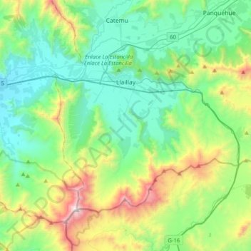
Name: Llay-Llay topographic map, elevation, terrain.
Average elevation: 777 m
Minimum elevation: 292 m
Maximum elevation: 2,217 m
Thank you for supporting this site ❤️
Make a donation
Make a donation
Gear up for your next adventure:
As an Amazon Associate, this site earns from qualifying purchases at no extra cost to you.
Other topographic maps
Click on a map to view its topography, its elevation and its terrain.
El Cobre
Chile > Valparaiso Region > Provincia de San Felipe de Aconcagua > Catemu
Average elevation: 547 m
La Chupalla
Chile > Valparaiso Region > Provincia de San Felipe de Aconcagua > Llay-Llay
Average elevation: 850 m