
Lasne topographic map
Interactive map
Click on the map to display elevation.
About this map
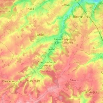
Name: Lasne topographic map, elevation, terrain.
Location: Lasne, Nivelles, Walloon Brabant, Wallonia, 1380, Belgium (50.64394 4.39485 50.72418 4.52638)
Average elevation: 107 m
Minimum elevation: 39 m
Maximum elevation: 150 m
Other topographic maps
Click on a map to view its topography, its elevation and its terrain.
Waterloo
Belgium > Walloon Brabant > Nivelles
Waterloo, Nivelles, Walloon Brabant, Wallonia, 1410, Belgium
Average elevation: 112 m
Braine-l'Alleud
Belgium > Walloon Brabant > Nivelles
Braine-l'Alleud, Nivelles, Walloon Brabant, Wallonia, Belgium
Average elevation: 116 m