Geolocate

Wheeling topographic map

Click on the map to display elevation.

About this map
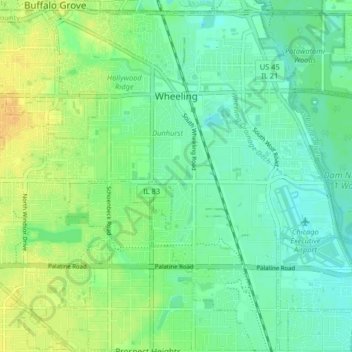
Name: Wheeling topographic map, elevation, terrain.

Location: Wheeling, Wheeling Township, Cook County, Illinois, 60090, United States (42.09517 -87.96116 42.15524 -87.88757)

Average elevation: 202 m

Minimum elevation: 192 m

Maximum elevation: 218 m

Other topographic maps

Click on a map to view its topography, its elevation and its terrain.
Symphony Lake

United States > Illinois > Cook County > Chicago

Average elevation: 181 m

Gear up for your next adventure:

🥾Hiking Gaiters - Protect legs and shoes from mud, snow, and debris
🧥Softshell Jacket - Windproof and breathable jacket for hiking
👖Convertible Hiking Pants - Zip-off legs to adapt to changing weather conditions
🔦LED Headlamp - Hands-free lighting for early morning starts or late finishes
🛌Insulated Sleeping Pad - Critical thermal barrier between you and the cold ground

As an Amazon Associate, this site earns from qualifying purchases at no extra cost to you.