
Thank you for supporting this site ❤️
Make a donation
Make a donation
Gear up for your next adventure:
As an Amazon Associate, this site earns from qualifying purchases at no extra cost to you.
İzmir topographic map
Click on the map to display elevation.
Thank you for supporting this site ❤️
Make a donation
Make a donation
Gear up for your next adventure:
As an Amazon Associate, this site earns from qualifying purchases at no extra cost to you.
About this map
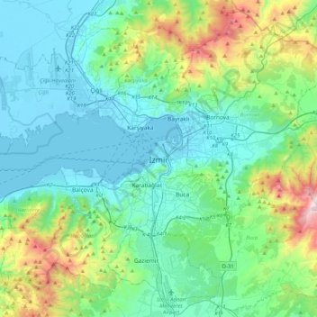
Name: İzmir topographic map, elevation, terrain.
Location: İzmir, Konak, Izmir, Aegean Region, 35250, Turkey (38.25925 26.96847 38.57925 27.28847)
Average elevation: 263 m
Minimum elevation: -4 m
Maximum elevation: 1,241 m
Thank you for supporting this site ❤️
Make a donation
Make a donation
Gear up for your next adventure:
As an Amazon Associate, this site earns from qualifying purchases at no extra cost to you.