Geolocate

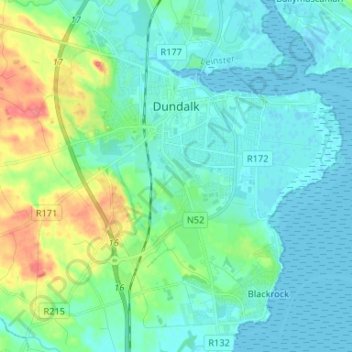
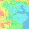
Dundalk topographic map

Click on the map to display elevation.

Dundalk

The main part of the census town lies at sea level. Dún Dealgan Motte at Castletown is the highest point in the urban area at an elevation of 60 m (200 ft). The municipal district includes the Cooley Mountains, with Slieve Foy the highest of the peaks at an elevation of 589 m (1,932 ft).

Wikipedia (CC-BY-SA 3.0)

About this map

Name: Dundalk topographic map, elevation, terrain.

Location: Dundalk, County Louth, Leinster, Ireland (53.95055 -6.44438 54.02793 -6.34154)

Average elevation: 13 m

Minimum elevation: -1 m

Maximum elevation: 59 m

Other topographic maps

Click on a map to view its topography, its elevation and its terrain.
Dundalk

Ireland > County Louth > Dundalk

Average elevation: 16 m

Drogheda

Ireland > County Louth > Drogheda

Average elevation: 38 m

Carlingford

Ireland > County Louth > Carlingford

Average elevation: 84 m

Blackrock

Ireland > County Louth

Average elevation: 5 m

Dromiskin

Ireland > County Louth > Dromiskin

Average elevation: 8 m

Collon

Ireland > County Louth > Collon

Average elevation: 146 m

Brookville Park

Ireland > County Louth

Average elevation: 26 m

Louth

Ireland > County Louth

Average elevation: 34 m

Tullyallen

Ireland > County Louth

Average elevation: 64 m

Slieve Foye

Ireland > County Louth

Average elevation: 287 m

Ravensdale

Ireland > County Louth

Average elevation: 124 m

Gear up for your next adventure:

🧣Evaporative Cooling Towel - Beat the heat during intense summer climbs
🧥Packable Rain Jacket - Breathable waterproof layer for unpredictable weather
🧰Survival Kit - Essential gear for emergencies in the wilderness
🗺️Topographic Maps - Detailed maps to explore trails, mountains, and wilderness areas
🦟Insect Repellent - Keep mosquitoes and black flies away in wooded areas

As an Amazon Associate, this site earns from qualifying purchases at no extra cost to you.