
Make a donation
Gear up for your next adventure:
As an Amazon Associate, this site earns from qualifying purchases at no extra cost to you.
Grassano topographic map
Click on the map to display elevation.
Make a donation
Gear up for your next adventure:
As an Amazon Associate, this site earns from qualifying purchases at no extra cost to you.
Grassano
Grassano is a town and comune in the province of Matera, in the southern Italian region of Basilicata. It is located between the Bradano and Basento rivers at an elevation ranging from about 150 to 576 metres (492 to 1,890 ft) above sea level. The town proper is 43 kilometres (27 mi) from Matera and 59 kilometres (37 mi) from the regional capital, Potenza.
Make a donation
Gear up for your next adventure:
As an Amazon Associate, this site earns from qualifying purchases at no extra cost to you.
About this map
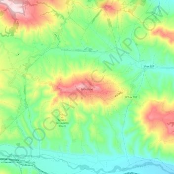
Name: Grassano topographic map, elevation, terrain.
Location: Grassano, Matera, Basilicata, 75014, Italy (40.58874 16.24061 40.67866 16.32242)
Average elevation: 297 m
Minimum elevation: 135 m
Maximum elevation: 603 m
Make a donation
Gear up for your next adventure:
As an Amazon Associate, this site earns from qualifying purchases at no extra cost to you.
Other topographic maps
Click on a map to view its topography, its elevation and its terrain.