Geolocate

Bennington topographic map

Click on the map to display elevation.

About this map
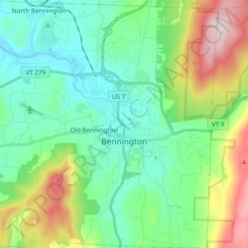
Name: Bennington topographic map, elevation, terrain.

Location: Bennington, Bennington County, Vermont, United States (42.83662 -73.27836 42.93442 -73.14600)

Average elevation: 352 m

Minimum elevation: 158 m

Maximum elevation: 860 m

Other topographic maps

Click on a map to view its topography, its elevation and its terrain.

North Pownal

United States > Vermont > Bennington County

Average elevation: 254 m

South Dorset

United States > Vermont > Bennington County

Average elevation: 377 m

Bondville

United States > Vermont > Bennington County > Winhall

Average elevation: 486 m

Bondville

United States > Vermont > Bennington County > Winhall

Average elevation: 486 m

South Dorset

United States > Vermont > Bennington County

Average elevation: 377 m

Gear up for your next adventure:

🧢Sun Hat - Wide-brim hat for sun protection
🧦Crew Hiking Socks - Comfortable socks for long-distance hikes
💡Solar Camping Lamp - Eco-friendly lighting for campsites
💡Portable Camping Lamp - Rechargeable lamp for campsite lighting
🧼Travel Hand Sanitizer - Keep hands clean when water is scarce

As an Amazon Associate, this site earns from qualifying purchases at no extra cost to you.