
Thank you for supporting this site ❤️
Make a donation
Make a donation
Gear up for your next adventure:
As an Amazon Associate, this site earns from qualifying purchases at no extra cost to you.
Thiniscole/Siniscola topographic map
Click on the map to display elevation.
Thank you for supporting this site ❤️
Make a donation
Make a donation
Gear up for your next adventure:
As an Amazon Associate, this site earns from qualifying purchases at no extra cost to you.
About this map
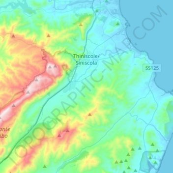
Name: Thiniscole/Siniscola topographic map, elevation, terrain.
Location: Thiniscole/Siniscola, Nuoro, Sardinia, 08029, Italy (40.47205 9.57968 40.61466 9.82932)
Average elevation: 222 m
Minimum elevation: -3 m
Maximum elevation: 1,056 m
Thank you for supporting this site ❤️
Make a donation
Make a donation
Gear up for your next adventure:
As an Amazon Associate, this site earns from qualifying purchases at no extra cost to you.
Other topographic maps
Click on a map to view its topography, its elevation and its terrain.