
Make a donation
Gear up for your next adventure:
As an Amazon Associate, this site earns from qualifying purchases at no extra cost to you.
Toms River topographic map
Click on the map to display elevation.
Make a donation
Gear up for your next adventure:
As an Amazon Associate, this site earns from qualifying purchases at no extra cost to you.
About this map
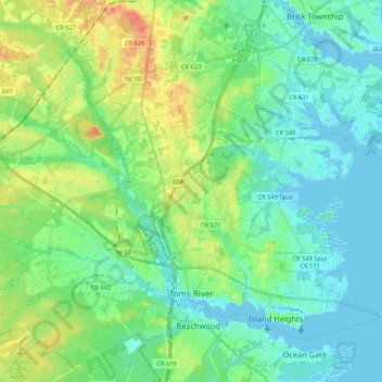
Name: Toms River topographic map, elevation, terrain.
Location: Toms River, Ocean County, New Jersey, United States (39.93300 -74.27067 40.05961 -74.05858)
Average elevation: 14 m
Minimum elevation: -3 m
Maximum elevation: 46 m
Make a donation
Gear up for your next adventure:
As an Amazon Associate, this site earns from qualifying purchases at no extra cost to you.
Other topographic maps
Click on a map to view its topography, its elevation and its terrain.
Chadwick Beach
United States > New Jersey > Ocean County > Toms River > Dover Beaches North
Average elevation: 0 m
Make a donation
Gear up for your next adventure:
As an Amazon Associate, this site earns from qualifying purchases at no extra cost to you.