
Make a donation
Gear up for your next adventure:
As an Amazon Associate, this site earns from qualifying purchases at no extra cost to you.
Ourika topographic map
Click on the map to display elevation.
Make a donation
Gear up for your next adventure:
As an Amazon Associate, this site earns from qualifying purchases at no extra cost to you.
About this map
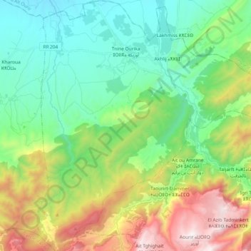
Name: Ourika topographic map, elevation, terrain.
Average elevation: 1,209 m
Minimum elevation: 741 m
Maximum elevation: 2,247 m
Make a donation
Gear up for your next adventure:
As an Amazon Associate, this site earns from qualifying purchases at no extra cost to you.
Other topographic maps
Click on a map to view its topography, its elevation and its terrain.
Setti Fatma
Morocco > Cercle de Tahannaout دائرة تحناوت > Sti Fadma > Sti Fadma
Average elevation: 1,874 m
Timmgouist
Morocco > Cercle de Tahannaout دائرة تحناوت > Sti Fadma > Anemiter
Average elevation: 2,467 m
Talat Marghene
Morocco > Cercle de Tahannaout دائرة تحناوت > Aghouatim اغواطيم
Average elevation: 1,004 m
RP2030
Morocco > Cercle de Tahannaout دائرة تحناوت > Oukaimeden > Ait el Qaq
Average elevation: 2,502 m
Make a donation
Gear up for your next adventure:
As an Amazon Associate, this site earns from qualifying purchases at no extra cost to you.