
Thank you for supporting this site ❤️
Make a donation
Make a donation
Gear up for your next adventure:
As an Amazon Associate, this site earns from qualifying purchases at no extra cost to you.
Andalo topographic map
Click on the map to display elevation.
Thank you for supporting this site ❤️
Make a donation
Make a donation
Gear up for your next adventure:
As an Amazon Associate, this site earns from qualifying purchases at no extra cost to you.
Andalo
The town lies on the Paganella plateau, between the mountains Piz Galin, elevation 2,442 metres (8,012 ft), and Paganella, 2,125 metres (6,972 ft), and its territory is part of the Adamello-Brenta natural park.
Thank you for supporting this site ❤️
Make a donation
Make a donation
Gear up for your next adventure:
As an Amazon Associate, this site earns from qualifying purchases at no extra cost to you.
About this map
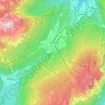
Name: Andalo topographic map, elevation, terrain.
Average elevation: 1,369 m
Minimum elevation: 655 m
Maximum elevation: 2,412 m
Thank you for supporting this site ❤️
Make a donation
Make a donation
Gear up for your next adventure:
As an Amazon Associate, this site earns from qualifying purchases at no extra cost to you.