Geolocate

Mount Juneau topographic map

Click on the map to display elevation.

About this map

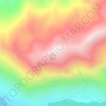
Name: Mount Juneau topographic map, elevation, terrain.

Location: Mount Juneau, Juneau, Alaska, 99802, United States (58.31891 -134.40867 58.31901 -134.40857)

Average elevation: 595 m

Minimum elevation: 0 m

Maximum elevation: 1,091 m

Other topographic maps

Click on a map to view its topography, its elevation and its terrain.

Auke Lake

United States > Alaska > Juneau

Average elevation: 61 m

Mendenhall Lake

United States > Alaska > Juneau

Average elevation: 152 m

Mendenhall Glacier

United States > Alaska > Juneau

Average elevation: 974 m

Mendenhall Valley

United States > Alaska > Juneau

Average elevation: 152 m

Herbert Glacier

United States > Alaska > Juneau

Average elevation: 989 m

Mendenhall Glacier

United States > Alaska > Juneau

Average elevation: 875 m

Gear up for your next adventure:

🛏️Sleeping Bag - Warm and compact sleeping bags for outdoor camping
🥾Lightweight Hiking Boots - Boots for comfort and mobility on long hikes
🎒Hiking Backpack - Lightweight and ergonomic backpacks for day hikes or multi-day treks
🦟Insect Repellent - Keep mosquitoes and black flies away in wooded areas
🥾Hiking Boots - Sturdy boots providing ankle support and traction on rugged trails

As an Amazon Associate, this site earns from qualifying purchases at no extra cost to you.